Noto quake 3D model adds dimension to understand earthquake dynamics
On New Year's Day 2024, a massive 7.5-magnitude earthquake struck the Noto Peninsula in north central Japan, resulting in extensive damage in the region caused by uplift, when the land rises due to shifting tectonic plates. The observed uplift, however, varied significantly, with some areas experiencing as much as a 5-meter rise of the ground surface. To better understand how the characteristics of the affected fault lines impact earthquake dynamics, researchers in Japan used recently developed simulations to make a detailed model of the fault. The findings could help develop models to simulate scenarios of different earthquakes and mitigate disasters in the future.
The results were published in the journal Earth, Planets and Space as a Frontier Letter.
"During the Noto Peninsula earthquake, we saw devastating uplift in some areas compared to others. In this study, we set out to understand the mechanism controlling the magnitude and spatial and temporal variation of fault slip and the resulting ground surface uplift," said Ryosuke Ando, an associate professor in the Graduate School of Science at the University of Tokyo and lead author of the current study.
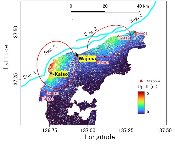
Spatial distributions of ground surface uplift captured by satellite observation and seafloor active faults. The areas of warmer colors experienced larger ground uplift during the earthquake. Traces of seafloor active faults (the cyan lines) run along the north off-shore of the Noto Peninsula. ?2025 Ryosuke Ando, The University of Tokyo
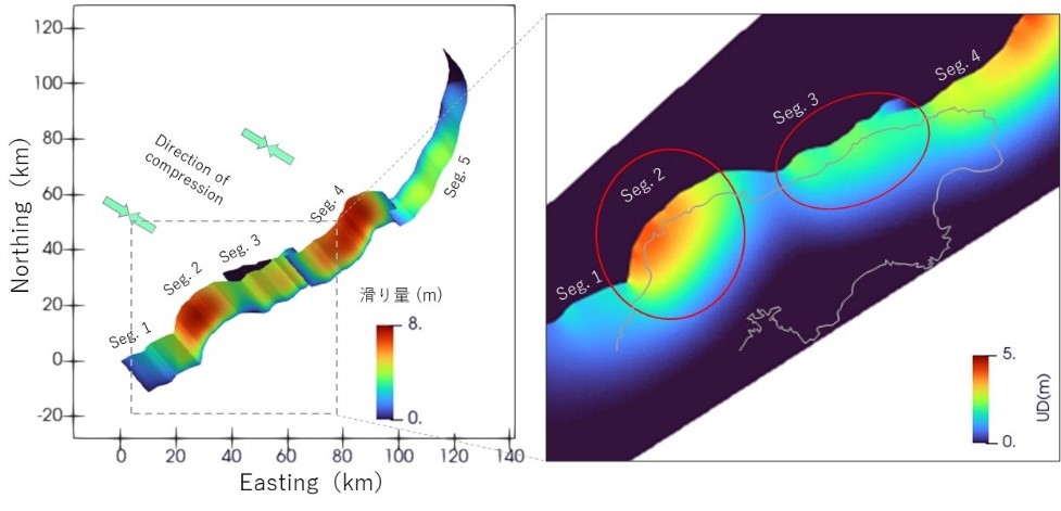
Simulation showing larger view of slip distributions on the fault and closeup of uplift. The fault slips significantly where fault segments are orthogonally oriented to the direction of the compressional stress (green arrows) acting in the tectonic plate because this is the condition when the faults slide effectively. The consistency with the observed surface uplift confirms the validity of the simulation result. ?2025 Ryosuke Ando, The University of Tokyo
Researchers wanted to develop a model of the 2024 earthquake that built on previous research and used observational data obtained before the earthquake occurred, such as characteristics of the faults involved and seismic activity preceding the devastating quake. If a simulation based on the real-world fault characteristics could accurately model what happened during the earthquake, it would help researchers understand how fault geometry - which describes characteristics such as the shape, orientation, different angles (including what are known as dip and strike) and direction of motion (slip) of the fault - affects earthquake dynamics.
There are three major faults involved in the 2024 Noto Peninsula earthquake. They are what are known as conjugate faults, i.e., faults with opposite sense of lateral movement. Two of them (the Monzen Fault, marked as Seg. 1 in the figures, and the Noto Peninsula Hoku-gan Fault Zones, Segs. 2-4) are southeast dipping, while the third (the Toyama Trough Sei-en Fault, Seg. 5) is northwest dipping. Dipping refers to the direction of the fault's incline. Observational data on fault traces (where faults intersect with the earth's surface) and the fault dipping angle were used to build the 3D fault geometry model. Data from previous seismic activity were used to establish the model of stress conditions. This area was subject to a localized, concentrated seismic swarm of smaller, shallower quakes for years leading up to the 2024 earthquake.
The simulation, developed with observational data of the fault geometry, was able to reproduce the variation in uplift that occurred during the 2024 Noto Peninsula earthquake. In some areas, uplift caused significant damage, while in others the effect was not as severe due to less prominent uplift. Based on the model of the Noto quake, vertical displacement was concentrated near the fault traces where the fault locally deviates from its overall horizontal orientation. This points to the fault geometry being key to how the earthquake affects the land.
"Our simulation with a supercomputer enabled the analysis of the three-dimensional fault geometry, which is irregularly shaped. We revealed that the fault geometry controlled the overall process through the relative fault orientations to the compressional force acting in the tectonic plate in this region," said Ando.
Looking ahead, the researchers are considering how this model could be used to develop better dynamic rupture scenarios for future earthquakes. "By demonstrating the potential of simulations with detailed models of fault geometries, we have shown how the characteristics of the fault slip pattern can be constrained before the occurrence of large earthquakes. We expect this finding to lead to building a method to assess the characteristics of hazards caused by future large earthquakes," said Ando.